FirstToSee

An Emergency Support System based on exsiting social media technologies

The FirstToSee is an Emergency Support System that leverages existing social media technologies to greatly improve emergency preparedness and management in the Puget Sound. This regional solution gives Western Washington responders the advantage of adding thousands of more eyes on the street. Responders can use the FirstToSee portal to gather and view large amounts of data from popular social media sites. FirstToSee uses advanced technology to compile this data into filterable and editable categories. Information can also be viewed in tabular and map format. Tabular view lists abbreviated data in expandable columns and gives the status and priority of each listing. Map view gives a real-time overview of locations and incident types.

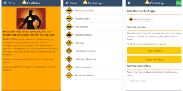
Meanwhile, the FirstToSee mobile app provides the public with new tools for communicating directly with responders. Often it is the public who are the first to sense danger or help survivors immediately following a disaster. The app allows users to send emergency reports and photos from their  smartphones or tablets. These reports are available in the FirstToSee portal in near-real time. Furthermore, the app has a “trusted user” function that will highlight reports submitted by public employees or vetted volunteers.

FirstToSee is a revolutionary system that makes it easy for responders to gather and review information from multiple social media outlets. The system uses open-source technology such as SwiftRiver and CrowdMap for data collection and interactive mapping.The FirstToSee portal gathers data from major information sources such as government reports, social media, and news feeds. Data from these “rivers” is then organized into filterable, editable categories known as “buckets.” System users can create “buckets” based on keywords or hash tags such as trapped, earthquake, fire or injured. To increase efficiency, these buckets can be set as broad subjects (earthquakes) or targeted to a single event (collapsed West Seattle bridge).
The system then drops any relevant tweet or report into the appropriate bucket. FirstToSee also makes it simple to switch between tabular and map views. The tabular view lists abbreviated data in expandable columns and gives the status and priority for each report. A simple click provides key details such as incident type, description, date submitted, attached photos, etc. The map view provides a real-time overview of locations and incident types. Users can simply click on icons to see photos and details of what is happening at a given location. The FirstToSee public app gives emergency responders the advantage of adding potentially thousands of more eyes on the street.
With the FirstToSee mobile app, citizens can easily send a detailed emergency report using their mobile device. Users can take a photo, select a type of incident from a predefined list, and the app automatically maps the user’s location and submits the report to the portal’s database in near real-time. Citizens can enter their contact information or submit a report anonymously. The app also has a “trusted user” function that will highlight reports sent from responders, public employees, or trusted emergency volunteers.

FirstToSee is currently available in the Puget Sound Area, but will eventually be made available to other regions. Regions or states that are interesed in using this application for themselves, can contact Eric Holdeman at ericholdeman@ericholdeman.com.