OpenTreeMap

Enables individuals, organizations, and governments to collaboratively contribute to an interactive and dynamic map of a community’s tree population

Urban street trees have myriad proven benefits for communities including providing shade, improving air quality, assisting with stormwater runoff, raising property values,etc.

While tree inventories provide municipalities with vital data to consult when managing the urban forest, creating a complete inventory is a time consuming and resource intensive process.

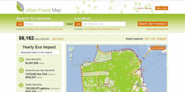
OpenTreeMap provides an easy-to-use public inventorying platform that enables individuals, organizations, and governments to collaboratively contribute to an interactive and dynamic map of a community’s tree population. OpenTreeMap can be used in a single municipality or cover a broader geographic region with many communities, anywhere in the world.

  • Search for trees by species, location, or advanced filters such as diameter, date planted, or tree characteristics (flowering, native, etc.)
  • Add trees individually or load tree datasets to the system
  • Edit and add information about existing tree records including species name, location, height, plot size and type, conditions, actions needed, funding sources, data owner
  • Upload tree photos
  • Export tree lists as KML or CSV files
  • Automatically calculate ecosystem benefits (greenhouse gas, water, energy,  air quality) based on a tree’s species and diameter
  • Monitor user accounts, comments, and system edits
  • Get optional integrated tree key to assist in identifying tree species