PetaJakarta.org

A web-based platform that shares real-time flood information using social media

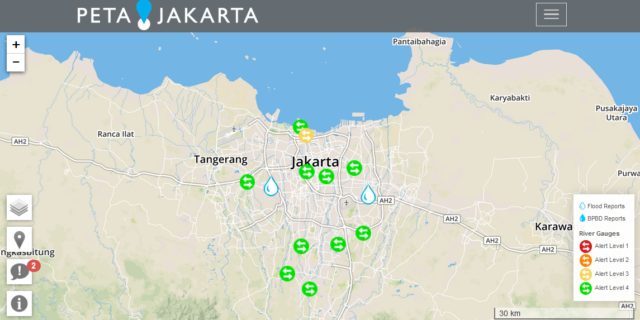
PetaJakarta.org is a research project that harnesses the power of social media to gather, sort, and display information about flooding for residents in real time. It enables citizens to report the locations of flood events using the social media network Twitter, thereby contributing to a web-based, publicly accessible, real-time map of flood conditions at PetaJakarta.org.

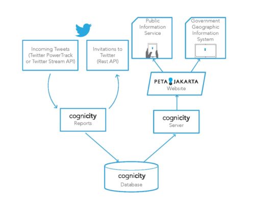
The platform runs on the open source software CogniCity. This geosocial intelligence framework allows data to be collected and disseminated by residents through their location-enabled mobile devices to map flooding and water infrastructure in real-time.

PetaJakarta.org has demonstrated social media’s valuable niche within the disaster risk management information ecosystem; as an operational tool capable of providing decision support at the various spatial and temporal scales required by the different actors within city, PetaJakarta.org offers an innovative and inexpensive method for the crowdsourcing of time-critical situational information in disaster scenarios.


  • Watch the video here.
  • Download the Whitepaper here.

PetaJakarta.org runs on the open source software CogniCity. CogniCity is an open source framework for urban data, which harnesses the power of social media by gathering, sorting and displaying real-time situational reports from urgent infrastructure issues such as flooding. The CogniCity toolset, first trialed through the PetaJakarta.org pilot study, makes crowd-sourced information available in real-time to citizens in need of daily information, and to government agencies to support decision making using a strategy of civic co-management. CogniCity builds on Geographical Information Systems (GIS) theory, to gather citizen reports from the social media network Twitter and create geospatial visualisations of this information.

petajakarta

System Architecture

However, CogniCity extends the traditional GIS paradigm to facilitate the process of citizen Twitter reporting by programmatically sending “invitation tweets” to users in the city who use the keyword “banjir” (flood). Reports are collected in a centralised geospatial database, and served via a data API to a client-side rendered map showing activity across the city in real-time, or as a data layer within external organisation geographical information systems.

petajakar  
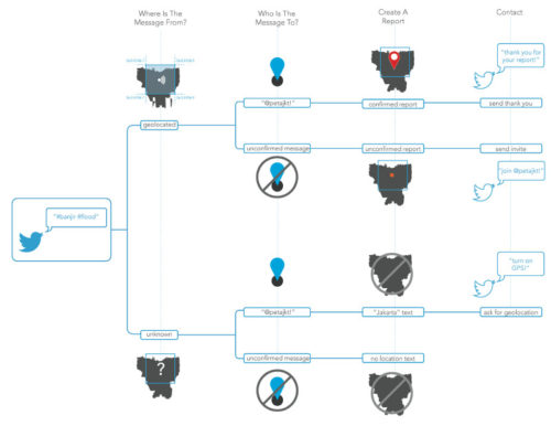
Process of Classifying and Responding to Tweets

PetaJakarta.org is a world-first Joint Pilot Study initiated by the SMART Infrastructure Facility, University of Wollongong, in collaboration with the Jakarta Emergency Management Agency (BPBD DKI Jakarta) and Twitter Inc. The study aims to research and develop open source software (OSS) for the integrated management of social media and API-sourced data in order to make risk information open, accessible, and actionable by residents, government agencies, NGOs, and private sector developers.

The Joint Pilot Study for this project was operationally active from December 2014 to March 2015. The collected data were used by BPBD DKI Jakarta to cross-validate formal reports of flooding from traditional data sources, supporting the creation of information for flood assessment, response, management in real-time. The following figure shows a chart of the five main flood events for the pilot period in relation with the twitter impressions.

wp_fig17

Chart of Five Flood Main Events for 2014-15