WaterSim

An urban simulation tool that estimates water supply and demand

WaterSim is a simulation model created to estimate water supply and demand for the Phoenix Metropolitan Area. Users can explore how water sustainability is influenced by various scenarios of regional growth, drought, climate change impacts and water management policies.

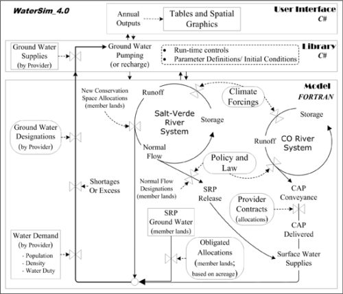
WaterSim is a systems dynamics model, as it takes a lot of data that is usually collected separately – including water supply, water demand, climate, population and policy data – and puts it together to give the user a system-level view of how these variables interact. It is “dynamic” because users can change one variable and see how that change affects the other variables.

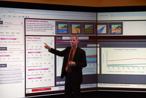
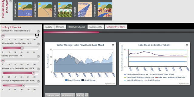
WaterSim emphasizes the role of visualization in helping to make data intelligible and accessible to stakeholders and decision-makers. Rather than poring over pages upon pages of charts and tables, users can view the data in graphic form. They can make side-by-side comparisons to understand how one variable relates to another. Launched in 2007, WaterSim is now in its fifth iteration, and can be viewed online, through a web API, or in person at ASU’s Decision Theater. It is an open source model that can be dowloaded from the DCDC’s website and the WaterSim 5.0 is being developed in FORTRAN and C#, with a documented application interface (API).

watersim_1

WaterSim allows users to change variables one-by-one, and then see how each change affects the water sustainability of the region and its various communities. By understanding best- and worst-case climate scenarios and the influence of various policy options on water supply and demand, decision makers can make choices informed by the best science available.

 WATERSIMm

  • Water Supply: How much water is available, and where does it come from? The Phoenix Metropolitan Area receives its water from many sources including river water, groundwater and water reuse. Water supply is primarily influenced by climate.
  • Water Demand: Which communities use the most water per person? How much will those communities grow? Does that community have agriculture? How efficiently is water used? Water demand is primarily influenced by policy and population growth.
  • Climate Change: We cannot predict exactly how climate will affect water supply and demand in the future. What we can do is look at past patterns – decades with high flows, low flows or high variability from year to year – to understand best- and worst-case scenarios.
  • Population Growth: The population of Great Phoenix has been steadily growing for decades. Will it continue to grow at this pace, or will it grow faster or slower than predicted? WaterSim users can create best- and worst-case scenarios by changing this variable.
  • Policy Decisions: Who gets to use the water that is available? Individuals, businesses, farmers and ecosystems all require water, and some water must be stored for future use, as well. WaterSim users can manipulate allocation of water for these various uses.

Initially, the application has been used by the Phoenix Metropolitan Area, in order to forecast different scenarios and support the decision making process. Since then, this tool has been used in various researches for other regions, such as Maricopa County and New Delhi.