-
ICOS / Applications / Generic / Data related
Applications for Data related
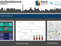
![](https://icos.urenio.org/wp-content/uploads/2017/05/mapzen-200x150.jpg)
Mapzen
An open, sustainable and accessible mapping platform
Development Agency: Sense.city
Civic Function: Data related, Generic
Software Type: City Representation
![](https://icos.urenio.org/wp-content/uploads/2016/09/Capture-200x150.png)
CogniCity
An open framework for urban data
Development Agency: University of Wollongong's SMART Infrastructure Facility
Civic Function: Data related, Generic
Software Type: Citizen Aggregation
![](https://icos.urenio.org/wp-content/uploads/2016/09/dublin-e1473417078412-200x150.png)
Dublin Dashboard
An interactive platform that provides real-time information about all aspects of the city
Development Agency: The DublinDashboard has been developed by The Programmable City project and the All Island Research Observatory (AIRO) at Maynooth University, working in collaboration with Dublin City Council.
Civic Function: City functions related, Data related, Generic, Sensors related
Software Type: City Services
![](https://icos.urenio.org/wp-content/uploads/2016/07/GvSIG_-_Geographic_Information_System-200x150.jpg)
gvSIG Desktop
A user-friendly, open source Geographic Information System (GIS)
Development Agency: gvSIG Association
Civic Function: Data related, Generic
Software Type: City Services
![](https://icos.urenio.org/wp-content/uploads/2016/05/Slide11-200x150.jpg)
OpenStack
A free and open source software platform for cloud computing
Development Agency: OpenStack Foundation
Civic Function: Data related, Generic, Sensors related
Software Type: City Services
![](https://icos.urenio.org/wp-content/uploads/2016/06/crowd_pybossa-200x150.jpg)
Pybossa
A crowdsourcing framework to analyze or enrich data that can't be processed by machines alone
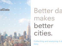
Development Agency: Scifabric
Civic Function: Data related, Generic
Software Type: City Decision-making, Planning and Management, City Services
![](https://icos.urenio.org/wp-content/uploads/2013/09/localdata_featured_image-200x150.png)
LocalData
LocalData is a digital toolkit that allows organizers and canvassers to collect and manage place-based data
Development Agency: Code for America fellows
Civic Function: Data related, Generic
Software Type: Location-based Service
![CKAN Featured Image](https://icos.urenio.org/wp-content/uploads/2012/06/ckan_featured_image-200x150.png)
CKAN
The open source data portal software.
Development Agency: Open Knowledge Foundation
Civic Function: Data related, Generic
Software Type: City Decision-making, Planning and Management
![All Our Ideas Featured Image](https://icos.urenio.org/wp-content/uploads/2012/06/allourideas_featured_image-200x150.png)
All Our Ideas
A suggestion box for the digital age.
Development Agency: Princeton University
Civic Function: Data related, Generic
Software Type: Citizen Aggregation
![Quantum GIS Featured Image](https://icos.urenio.org/wp-content/uploads/2012/06/qgis-200x150.png)
Quantum GIS
A user friendly, open source Geographic Information System (GIS).
Development Agency: OSGeo
Civic Function: Data related, Generic
Software Type: Location-based Service